Geospatial Analysis with Vector Data
-
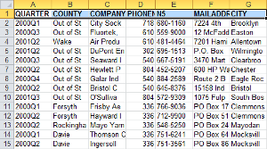
Data Cardinality
My GIS department has been contacted by our State representatives to analyze the results of an industrial extension jobs survey for the upcoming elections. The representatives are interested in showing how their policies have created jobs, and to compare their successes to neighboring districts. I will be making extensive use of both tabular and spatial joins to combine spatial data with the survey results.
Read more... -

Working with US Census Data
For this assignment I mapped the estimated median earnings for residents of Fulton County, Georgia from the last twelve months with data from the US Census American FactFinder. The table I used contained lots of information on earnings by demographics, gender, and education. The field I used from this table represents Total Estimate Median earnings (dollars) for a given census tract.
Read more... -
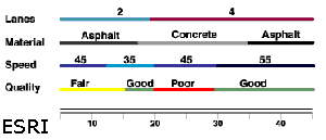
Linear Referencing
This assignment covers the use of GIS to apply attributes to specific segments of a line with a technique called Linear Referencing. More specifically I analyzed the occurrence of accidents along segments of a road network and compared those accidents against both the type of material of the road, and the road's condition.
Read more... -
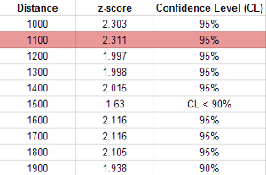
Spatial Statistics
The problem presented in this assignment is to apply spatial statistics methods to get a better understanding of the spatial distribution of Emergency Medical Service (EMS) calls. These tools generally find the presence or absence of clustering/dispersion on either attribute values, the geographic location itself, or both.
Read more...
subscribe via RSS